A Flow-Through Dam for Flood Control
A flood risk solution that serves the needs of fish, preserves the riverine ecosystem, and protects communities from major and catastrophic flooding.
 February 5, 2026 - Thank you to all who submitted comments on the SEPA Revised Draft EIS. The RDEIS and the District's comments and supporting materials are available on the Resources Page under "State and Federal Environmental Review."
How It Works
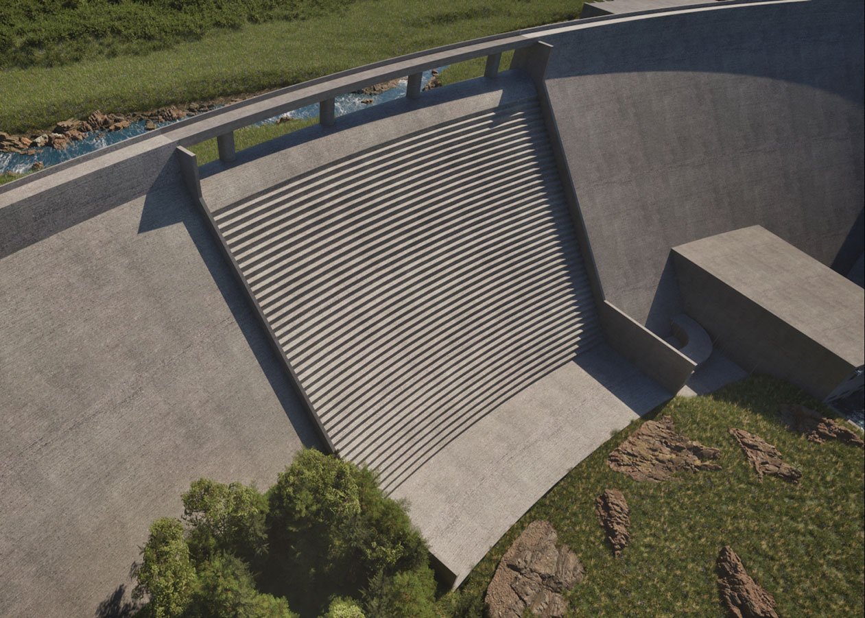
The flow-through dam for flood control balances flood risk reduction with natural biological and physical riverine processes. This innovative structure is designed to reduce damage from major and catastrophic flooding.
Most of the time, the Chehalis River will move through the flow-through dam for flood control, allowing fish to pass upstream and downstream on their own. During major floods, the flow-through dam will store water in a temporary reservoir and slowly release it back to the river as conditions return to normal. There will be no permanent storage of water, so in non-flood times, the river and its fish would move naturally through fish passage conduits in the facility.
FAQ
The project, which includes the flow-through dam for flood control and the airport levee improvements, will reduce the extent of flood damage to people, homes, businesses, farms, and transportation in the Basin. It will save hundreds of millions of dollars in damages during flood events, helping our communities bounce back more quickly and at a lower financial cost.1
Models estimate that the facility will:
- Prevent the inundation of 3,514 acres during a major flood and 3,795 acres during a catastrophic flood.2
- Eliminate flooding for about 1,280 structures.3
- Decrease flood damage to structures by 50-72%.4
- Protect up to 1,800 people from displacement.5
- Reduce the likelihood and duration of I-5 and airport closures.6
- Save hundreds of millions of dollars by reducing damage to structures, farms, and businesses and preventing transportation interruptions
The flow-through dam will not stop all flooding. The purpose of this structure is to help reduce damages associated with major and catastrophic flood events.
The flow-through dam is designed to operate only during major flood events, typically caused by extreme precipitation or atmospheric rivers. A major flood event is defined by a river flow of 38,800 cubic feet per second (cfs) at the US Geological Survey (USGS) stream gauge at Grand Mound. These events typically occur in the late fall through winter timeframe. The District is continuing to research this threshold for operating the dam and will refine operational plans as more information is gathered.
Flow rates have reached the 38,800 cfs threshold at Grand Mound three times in the past 20 years.7 Based on the hydrologic record, major floods currently have a 15% probability of occurring in any given year (an approximate 7-year recurrence interval) but are likely to occur more frequently in the future based on climate projections. The District is continuing to refine estimates for how often the flow-through dam will operate as part of ongoing operational refinements.
The flow-through dam can retain a reservoir in the upper Chehalis Basin of up to approximately 62,000 acre-feet of water or 20.2 billion gallons. For reference, Lake Union has a volume of about 6.5 billion gallons.
Retaining water during flood events will help protect Basin communities from flood damage by reducing the depth, extent, and duration of severe flooding.
Under the most common major flood events, the flow-through dam will retain water for approximately 32 days. Water will be released during that period at a rate that minimizes flood damage downstream while also maintaining the naturally occurring wintertime flows in that reach of the river. Water will always be flowing downstream, even while the flow-through dam for flood control is holding water in the reservoir.
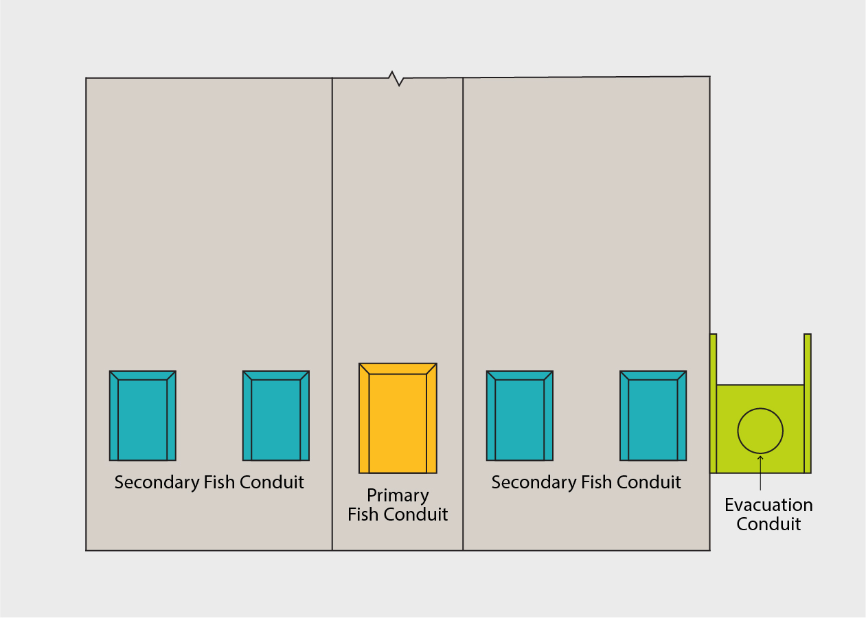
No, when the flow-through dam is not operating (which is almost all of the time), fish will be free to swim upstream and downstream past the facility. The fish passage conduits are designed to mimic the river, with similar depth and velocity, so fish can comfortably move through them. These conduits also allow for sediment and debris to pass through, which minimizes the disruption of ecosystem processes and maintains the natural river dynamics. Only during flood events, when water is being retained, would an advanced trap-and-haul facility be used to pass various fish species and life stages upstream.
All construction projects impact their surrounding environment, and mitigation is required to address these impacts. This is even more true for the flow-through dam because it is designed to balance two goals: reduce flood damage in the community and support a healthy ecosystem in the Upper Chehalis River Basin. The District’s Revised Mitigation Plan presents actions that will avoid, minimize, and mitigate the impact of the flow-through dam for flood control on fish and wildlife and their habitats, and includes a Revised Vegetation Management Plan to ensure healthy streamside vegetation remains upstream of the project. The goal of the Revised Mitigation Plan is to offset impacts and improve habitat function over existing conditions, providing an ecological lift for fish and wildlife.
Federal and state agencies will review the District’s mitigation plan. If the Revised Mitigation Plan is approved and implemented, it would, in combination with all other habitat restoration work under the larger Chehalis Basin Strategy, have Basin-wide benefits for fish, frogs, and many other native species that call the Chehalis River home.
Not only will the District be required to ensure that the flow-through dam does not change the function of the habitat for native species, but the District is committed to making sure that the river has healthier habitat than before the facility is built. The mitigation actions proposed by the District would address the potential impacts of the facility on aquatic resources and help to alleviate existing habitat factors that are thought to be limiting the health of native aquatic species. This means restoring some of the natural properties that have been degraded over time, such as planting native trees and shrubs along the stream bank to increase shade and cool the water, increasing habitat complexity by creating side pools, and opening fish access to blocked habitats through barrier removal.
FRE stands for “Flood Retention Expandable” and is the technical name for the flow-through dam for flood control on the Chehalis River. This is how the facility is referred to in the State and National Environmental Policy Act (SEPA/NEPA) documents.
The design of the flow-through dam is considered “expandable”, meaning it includes elements developed or designed to not preclude future expansion of the facility. To be clear, the current project does not include future expansion.
No, there are no plans to expand the facility at this time. Any expansion would be a separate project, subject to federal and state approvals, tribal consultation, public review, and environmental permitting; the facility is simply being designed to not preclude expansion.
Floods in the Chehalis Basin are defined by how fast water is flowing at the U.S. Geological Survey (USGS) Grand Mound gage, measured in cubic feet per second (cfs). When this flow rate reaches 38,800 cfs, it is called a major flood, which is similar to the 2009 flood event. Major floods are sometimes called 7-year floods because that is about how often they are expected to occur. When the flow rate reaches 75,100 cfs, it is defined as a catastrophic (or 100-year) flood, which is similar to the 1996 flood. The 2007 flood was even larger than a catastrophic flood and is categorized as a 500-year flood.8
Why We Need a Flow-Through Dam for Flood Control
This structure is needed to protect the Chehalis Basin community, especially those most vulnerable, from severe economic, social, and environmental consequences.
Inaction is not a viable option.
Economic
- Lack of action in the basin could cost Washington as much as $3.5 billion during the next 100 years.9 Expenses could include:
- Repairing or replacing flood-damaged homes, businesses, and public infrastructure.
- Disruptions to local community, economic, and agricultural activities from flooding.
- Interruptions to state road and rail transportation corridors because of flooding.
- Mitigation efforts for continued aquatic habitat degradation and loss.
- Indirect costs of an I-5 closure – relating to commerce, food supplies, and public health.
- The 2007 flood alone resulted in monetary damages of $900 million.10
Social
- Impacts of flooding are felt by everyone in the community – an estimated 12,483 people living in the climate-modeled floodplain – and adversely affect the ability for all to meet their basic needs.11
- The community’s most vulnerable members are disproportionately impacted.
Environmental
- Although flooding is a natural process in the region, the increased frequency of major and catastrophic flooding negatively impacts aquatic habitat.
- Floodwaters can be toxic and polluted.
- Impacts on fish and aquatic species from flooding require mitigation. Mitigation will be incorporated into the flow-through dam for the flood control project itself; in contrast, inaction will not mitigate the known negative effects of flooding on aquatic species.
Design Updates
In 2020, the Washington State Department of Ecology and the U.S. Army Corps of Engineers released their respective Draft Environmental Impact Statements (DEISs), which described potential impacts on environmental resources from the construction and operation of the flow-through dam for flood control.
To address the findings described in the DEISs, the flow-through dam for flood control has undergone considerable design revisions, and the mitigation plan has been enhanced to provide a robust suite of actions that target multiple natural resources.
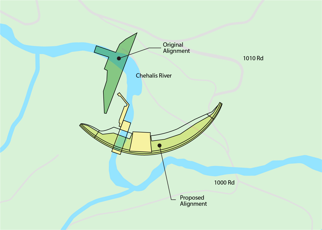
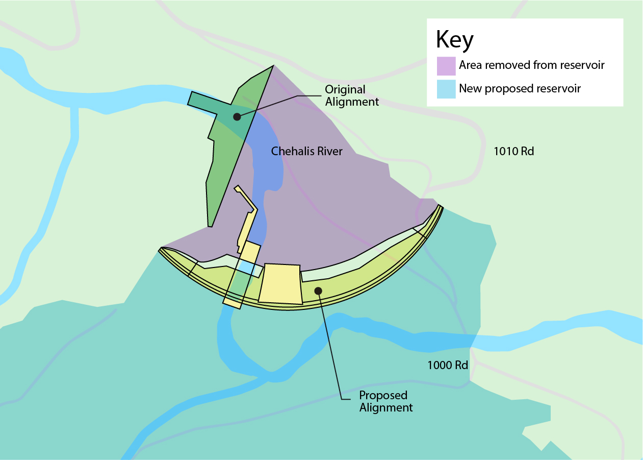

Click image to enlarge
Project Schedule
The following timeline highlights significant milestones that have led to the development of the flow-through dam for flood control.
-
1996 Flood
Hundreds of community members fled to emergency shelters at Centralia Middle School, Edison Elementary School, R.E. Bennett Elementary School, the Randle Fire Department, Adna High School, the Grand Mound Baptist Church, and Bucoda church.12 -
2007 Flood
The financial loss from the 2007 flood totaled $512 million. This total includes residential, small and large business, agriculture/farm, public infrastructure, government revenue, local agencies, state agencies and parks, and federal agency losses.13 -
2009 Flood
A twenty-mile stretch of I-5 was closed for two days. The economic cost of the closure to the state was roughly $4 million a day.14 -
2012 Funding for protection projects begins
A twenty-mile stretch of I-5 was closed for two days. The economic cost of the closure to the state was roughly $4 million a day.15 -
2016 Action mandated by legislature
The Washington State Legislature passes House Bill 2856, creating the Office of Chehalis Basin (OCB), Chehalis Basin Board, and Chehalis Basin Strategy. -
2017 Submission of conceptual design report
The Flood Control Zone District (FCZD) submits the Combined Dam and Fish Passage Conceptual Design Report. -
2018 Submission of FRE dam alternative report
The FCZD submits the Combined Dam and Fish Passage Supplemental Design Report FRE Dam Alternative (the technical name for the flow-through dam for flood control). -
2020 Release of Draft Environmental Impact Statements (DEIS)
The Washington State Department of Ecology and U.S. Army Corps of Engineers conduct and release DEISs to identify probable impacts and mitigation. -
2022 Flood
Twenty miles of I-5 was shut down for several hours and more than 250 homes and businesses were damaged from the flood.16 -
2024 Submission of Revised Project Description Report
The FCZD develops and releases the Revised Project Description Report, which explains design revisions to the FRE that address issues identified by the DEISs. -
2024 Submission of Revised Mitigation Plan
Anticipated updates are made in a Revised Mitigation Plan to help address many of the impacts outlined in the DEIS. -
Future Anticipated actions
- The Washington State Department of Ecology and U.S. Army Corps of Engineers will develop Final Environmental Impact Statements.
- The OCB Board will officially vote on a flood risk reduction alternative.
1 Comprehensive Flood Hazard Management Plan (CFHMP) (2021), p. 136
2 State Environmental Policy Act Draft Environmental Impact Statement (SEPA DEIS) (2020), p. 117
3 SEPA DEIS (2020), p, 118
4 CFHMP (2021), p. 135-136
5 CFHMP (2021), p. 136
6 SEPA DEIS (2020), p. 172
7 USGS Peak Streamflow at the Grand Mound gage (2024)
8 SEPA DEIS (2020), p. 30, 45
10 Chehalis Basin Flood Hazard Mitigation Alternatives Report (2012)
11 CFHMP p82
12 The 1996 Flood — Day by Day | The Daily Chronicle (chronline.com)
13 Dec. 3, 2007 - Chehalis River Flooding Even Description
14 City of Chehalis Floodplain Management Property in Floodplain Letter
15 History of the Chehalis Basin Strategy
16 Recovery slows for communities hit by Chehalis River flooding in January | Fox 13 Seattle
Over 65 years old
Living with a disability
Living below poverty line